

1 ASX.SPX Announcement 16th October 2018 “SPX acquires one of the highest grade historic open pit gold mines in WA”
2 ASX.AUE Announcement 8th March 2022 Penny South Drilling Programme Completed
3 ASX.AUE Announcement 29th October 2021 “Prospectus”

Highlights

The Penny South Gold Project is located in a world class gold district and ~550m south of one of Australia’s highest grade producing gold mines1, the Penny West/North Gold Mine, owned and operated by Ramelius Resources Limited (ASX:RMS)
The tenement (E57/1045) is located approximately 450km northeast of Perth and 100km southwest of Sandstone and currently consists of 4 blocks covering 9.95km2.
Average historical drill hole depth across E57/1045 is ~42m, with only 18 holes deeper than 100m and 7 holes deeper than 200m2,3, with no diamond drilling.

Overview
The Penny South Gold Project (E57/1045) (Figure 1) lies only 550m south of Ramelius’ operating Penny West/North gold mine project (Figure 2), which is estimated to contain 440,000t of ore at 22g/t Au (320,000oz Au) (“Penny”)4. Strata Minerals’ Penny South Gold Project captures a ~2.5km strike extension of the Penny West Shear immediately south of Ramelius’ Penny deposits, southern Youanmi Greenstone Belt (Figure 3).
The tenement (licence E57/1045) is located approximately 450km northeast of Perth and 100km southwest of Sandstone (Figure 1) and currently consists of 4 blocks covering 9.95km2. Access to the tenement is via the Great Northern Highway and the unsealed Paynes Find to Sandstone Road as far as Youanmi and then southwards on the Youanmi to Lake Barlee Road. Access within the tenement area is via fence line tracks and historic exploration tracks.
Historic drilling at the Penny South Gold Project has encountered various significantly anomalous intersections of gold mineralisation, which are currently being compiled and assessed. Over 1,000 drill holes have been completed within E57/1045, mostly RAB and AC holes with RC holes accounting for only ~3% of the drill holes. The average downhole length of the historic drill holes within the Penny South Gold Project is ~42m with only 18 holes deeper than 100m and 7 holes deeper than 200m. There has been no diamond drilling completed at Penny South.
Spectrum Metals Limited, which owned the Penny West Project prior to being taken over by Ramelius in 2020 for ~$215M, reported outstanding exploration success at Penny North and at the southern end of the Penny West pit within deeper drill holes beneath cover. Strata Minerals intends to utilise a similar exploration strategy to reinterpret all available data and to test targets at depth.
4 ASX:AUE Announcement , Ramelius Resources Limited (ASX:RMS) Diggers and Dealers presentation 5th August 2024
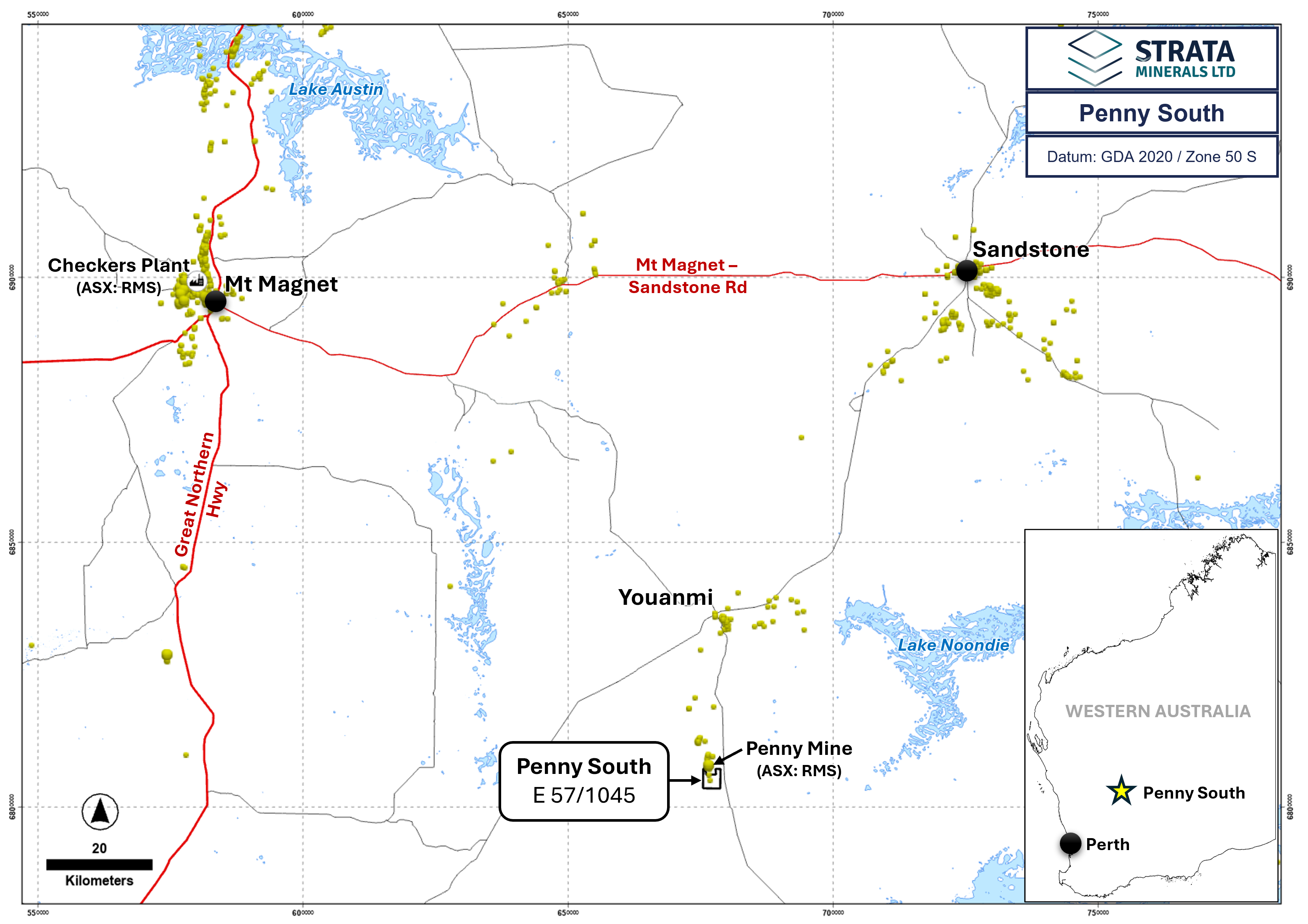
Figure 1: Location of the Penny South Project (E57/1045).
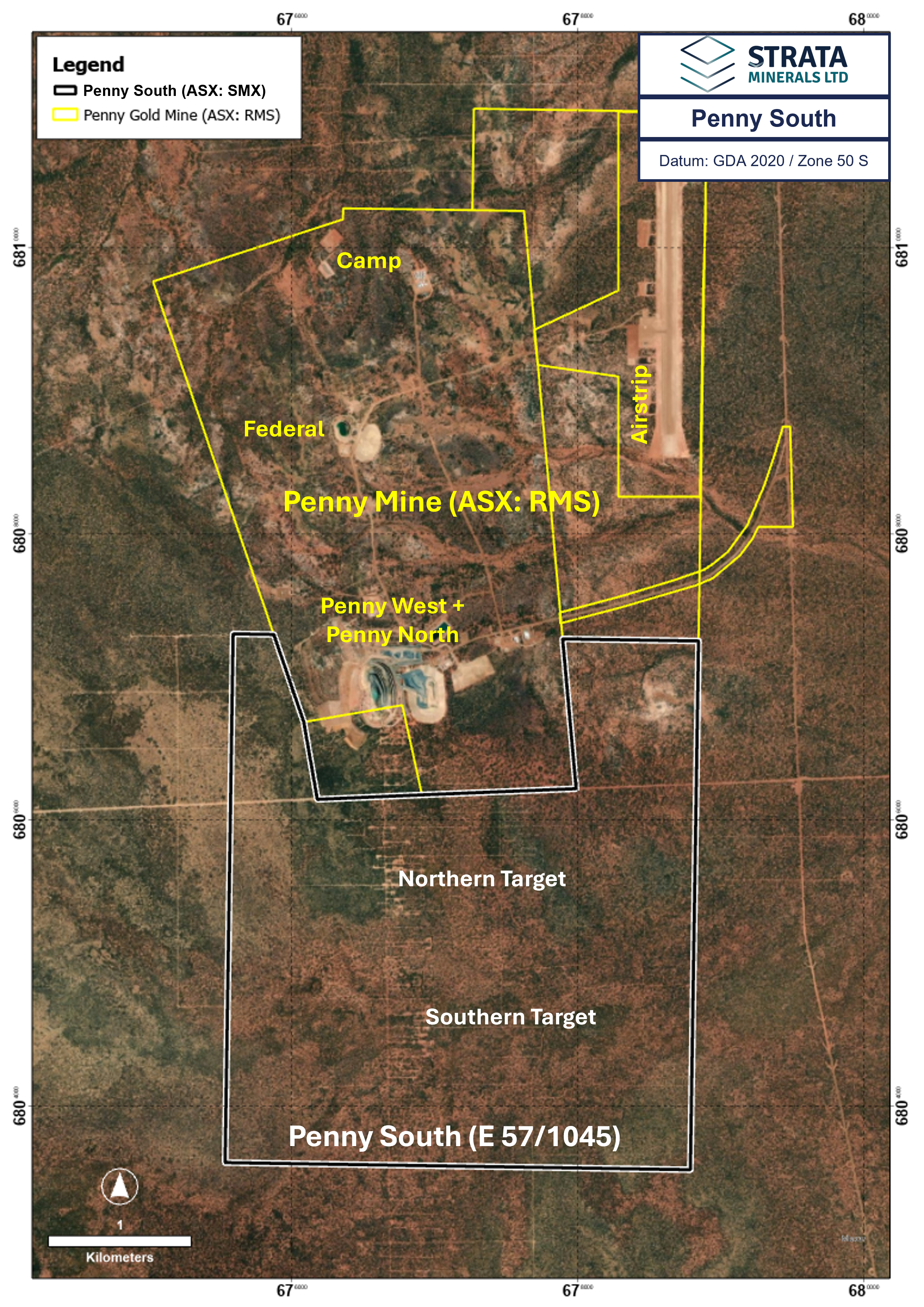
Figure 2: Penny South Project (E57/1045) immediately south of the high-grade Penny West/North (Penny) Gold Mine owned and operated by Ramelius Resources Limited (ASX:RMS).
Geological Summary
Tenement E57/1045 is located at the southern end of the Youanmi Greenstone Belt, which straddles the boundary of the Murchison and Southern Cross Domains that is marked by the regionally extensive Youanmi shear zone.
The Project lies to the south of the historic Penny West gold mine and covers approximately 2.5km of strike of the Youanmi Greenstone Belt, dominated by mafic and ultramafic rocks (Figure 3). There is very little outcrop of the Archaean basement lithologies with the vast majority of the Project area covered by aeolian sand and other transported sediments reportedly up to 30m thick, averaging around 10m in thickness.
Gold mineralisation at the Penny South Gold Project is controlled by the Youanmi shear zone and hosted in the hangingwall of mafic schists. Historic drilling across E57/1045 reveals a sequence of north-south striking mafic and ultramafic rocks of variable magnetic intensity from non- to moderately magnetic. Analytical and lithological data suggest that the historic gold intercepts are associated with quartz veins, sheared geological contacts and granodiorite.
The Penny West gold mine host stratigraphy to the north is a sequence of steeply dipping mafic and ultramafic rocks with minor felsic intrusive where gold mineralisation is associated with steeply east dipping quartz-sulphide veins up to 5m in width. The Penny West mineralisation at the base of the historic open pit (80m depth) to the base of drilling at 220m depth indicates the mineralised lode dips to the east at 65-80° with strike extent of 300m. The main lodes typically have sharp boundaries controlled by shears and minor zones of discontinuous mineralisation occur in the hangingwall of the main lodes. The deposit is characterised by structurally controlled gold-quartz veins in a brittle-ductile shear zone. High grade gold is typically associated with sulphides such as pyrite, pyrrhotite, galena, sphalerite and chalcopyrite.
Mineralisation at Penny North is considered contemporaneous in origin to Penny West and is characterised by abundant vein quartz and sulphides. From drilling, the mineralisation has been interpreted to have an upper limit of 80m below surface and extend to a depth of 320m below surface with the orebody modelled as a gently south plunging shoot with a north-south extent of 400m and a vertical extent of 240m. The mineralisation is developed along a contact between gabbro and granodiorite. Wallrocks are typically mylonitic and display albite and sericite alteration. The quartz veins are variably massive, laminated or brecciated with a highly variable sulphide assemblage of pyrite, pyrrhotite, galena, sphalerite and chalcopyrite.
5 ASX:AUE Announcement 29th October 2021 “Prospectus”
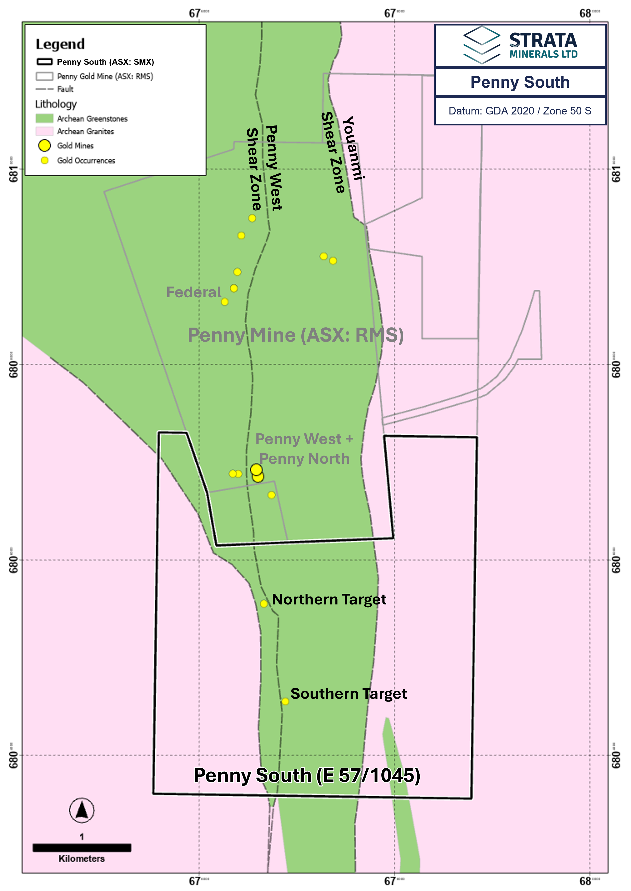
Figure 3: Local geology highlighting the Penny West Shear Zone at the Penny South Project (E57/1045)